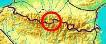
|
The
bordermarkers of the Pyrenees : all markers
 |
|
| Bordermarker 359: two theories |
 |
| The
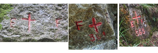
bordercros bm359 - engraved in 1863 - has never been refound. Jean Sermet was convinced that a
4x10m rockface on the
steep hillside between bm358 and 360 must have been the original spot and in 1957 he engraved
a cross there. In 2009 Paco Nudels discovered a cross on a similar
looking rockface. But: is this the same cross as Jean Sermet engraved? And was this rock the very spot of the original bm359? I listed all available evidence and tried to answer the questions. I have developed two theories on this subject: - theory 1: the original bm359 was engraved at that steep hillside but 75m E of Paco Nudels' cross - theory 2: the original bm359 was engraved at the beginning of the steep hillside -> the most likely option, I think. | |
|
THEORY 1 |
|
 |
Charles and Josette Darrieu searched
for bm359 several times without success, despite using a gps and measuring
the distance with a rope from bm358. But in 2009 Paco Nudels sent them gps-coordinates and a picture of a cross and - checking their own gps-tracks - realized that they had been very close. |
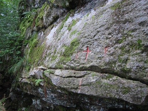
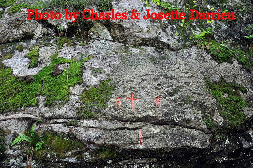 | In
2010 Charles & Josette Darrieu returned and found the cross
of Paco Nudels. Their conclusion is firm: this cross must be considered as the successor of the lost bm359, underlining the arguments of Jean Sermets. NB: they insisted that Paco Nudels should be mentioned as the one who discovered this bm and the route to it. So let's call it: "Paco's cross". |
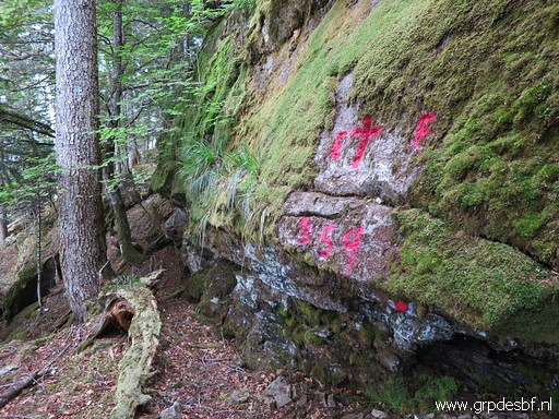
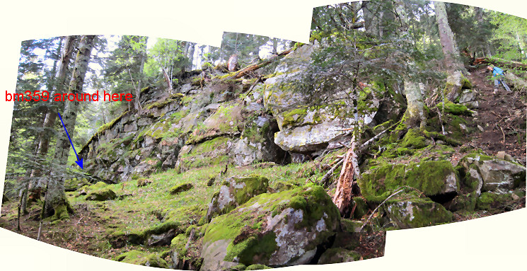
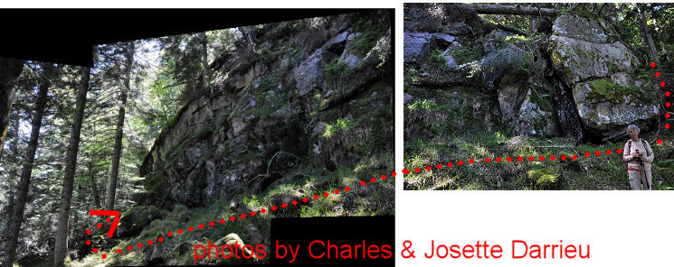 And this set of pictures shows a rockwall of several meters high and more than 10 meters long. Paco's cross is situated to the far left of this boulder and the dotted red line is the access route from the Darrieu's. | |
 |
I couldn't find bm359 on 20100911 but was able to find this cross - thanks to the gps-data of Paco and Charles & Josette on: 20110901 (more pictures on that page) But I was doubtful about the exact status of this cross. |
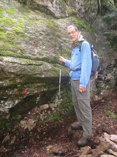 |
Then in 2013 Jacques Koleck and his brother
visited the site and examined thoroughly the soil and underground
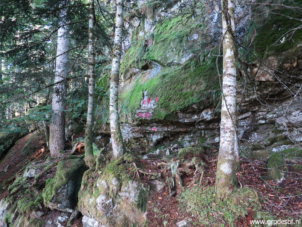
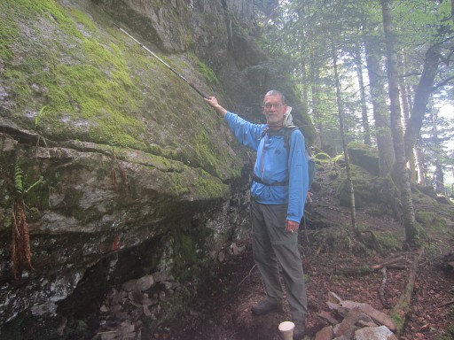
beneath the cross. At a depth of 30-40cm they found two flattened stones with traces of paint. Perhaps - suggests Jacques - the rockwall has collapsed partly. Jaques placed the two stones in the small niche under the cross. Perhaps he's the one who started to build the cairn which we now see at the foot of the cross. This picture: showing that niche underneath the cross. NB: the man is not Jacques Koleck but Jan-Willem Doomen. |
 |
I returned with Jan-Willem Doomen on 20140527 (more pictures on that page) |
|
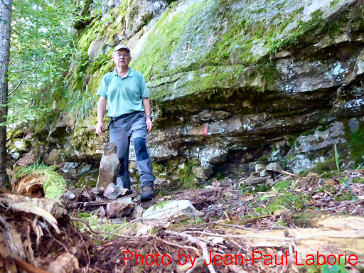
Jean-Paul Laborie - official delegate of the Pyrenean bordercommision - also payed a visit to the site on 3 october 2014. He considers the presence of the divisoria-markers on the trees nearby ánd a sort of cairn at its foot as a proof that this crosse was meant to be an official bordermarker. Considering that an engraved second cross - either below or above the current is not likely, he believes that this is is the original cross of 1862. But remember: the cairn was built in recent years and didn't exist before. |
 |
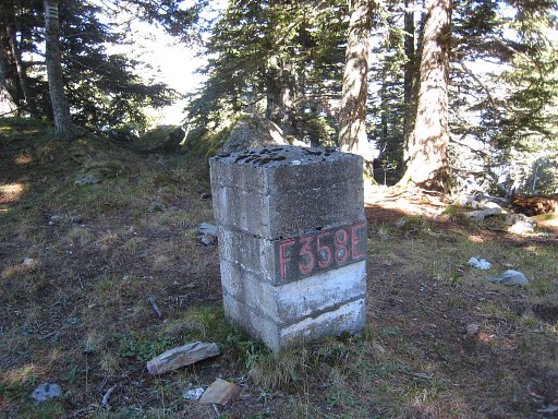
Bm359 Photographed on 20210611 (more pictures at that page) |
 |
Bm359 (click photo to enlarge) Photographed on 20210917 (more pictures at that page) |
THE SOURCES It's time to check the sources. However, we have - apart from the Treaty-text - only the writings of Jean Sermet as sources. Jean Sermet was a French bordermarker-official and -expert for many years. |
|
| Convention additionnelle au Traité de délimitation du 14 avril 1862, signée à Bayonne 356. Borne sur la limite du Clot de Barèges, touchant l'ancien repère et à 1058 mètres du Pic d'Aubas. D'ici la frontière monte en ligne droite au piton ou Tuc du Plan de la Serre, et se confond ensuite avec la ligne de crête jusqu'à la croix no 359. 357. Borne à ce piton, à sept cent dix mètres de la précédente. 358. Borne au camp de Enténès au bord du précipice et à 602 mètres de la borne antérieure. 359. Croix sur un rocher touchant le précipice, à 330 mètres de la borne antèrieure. A partir de ce point, la limite internationale abandonne la ligne de partage des eaux jusqu'au Portillon descendant d'abord sur le versant occidental pour passer ensuite sur le versant opposé et suivant l'ancienne démarcation entre Saint-Mamet et Bosost, laquelle a été signalisée par des croix nouvelles gravées à côté des premières. 360. Croix au lieu dit Peyres juntes ou Peyras quilladas, sur la face verticale du rocher, à gauche du sentier qui descend d'Espagne en France, et à 300 mètres d'un petit plateau situé sur la ligne des versants. Ce plateau est appelé de l'Artigue ou Plan de Artiga du coll de Barèges. La distance à la croix précédente n'a pas pu être mesurée, le terrain étant inaccessible entre les deux repères. De la croix no 360 jusqu'au Portillon, la frontière suit une percée faite dans la forêt. |
This is the original treaty-text. What does it tell us about bm359? Not much it seems at first sight: bm359 is a bordercross on a rock or boulder on the edge of a precipice, 330m from bm358. But there are two interesting additions (yellow) about the course of the borderline from bm357 to bm359 and beyond it. We will return to these phrases later. |
1957: Journal de la Restauration de l’Abornement de la Haute Garonne / by Jean Sermet After WWII France and Spain decided to restore their bordermarkers. Many of them had disappeared or ruined since the 19th century. Jean Sermet was a leading man in this proces and an industrious writer. In 1957 he describes how the bordermarkers 332 to 417 were checked and restored when needed. |
|
page 4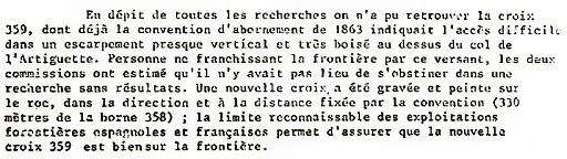 A new cross was engraved and painted on "the rock" in the direction and distance prescribed by the treaty. The spot was localized using the distance (330 meters from bm358) and following the 'divisoria'-markers between the french and spanish forests. These are markers like double red stripes on trees, painted and maintained by the foresters (I assume). Note: there's no mentioning of a number engraved. |
About bm359 Jean Sermet writes that this bordercross was unfindable despite "all searches". Considering that no one crossed the border on this steep hillside, the commission decided that further searching was useless. |
page 5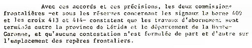 What does that mean: the new cross engraved by Sermet and his company - replacing the original but unfindable bm359 - should be considered as the official replacement of that lost bordermarker. But: is that the same cross which Paco Nudels found? |
The
'journal' ends with the conclusion that all delimitation works between
the province of Lérida and departement of Haute-Garonne are
finished and agreed upon between the French and Spanish commissions. |
1960 Abornement Haute-Garonne - Journal des operations / by Jean Sermet In 1960, the bordermarker-range 332-419 was rechecked in 9 daytrips. This 'journal' gives a vivid and detailed description of these trips. |
|
page 10 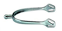 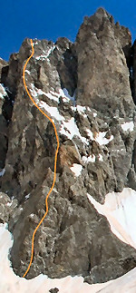 The
translation of : "éperon en dièdre marqué" is not easy. "Éperon"
translates as 'spur' but what is the meaning as a geophysical
description? If we search online we could translate it as a 'sharp
ridge'. We find this meaning on rockclimber's websites. But why didn't
Jean Sermet use the word "crête" (= ridge) when he meant a 'crête'? The
translation of : "éperon en dièdre marqué" is not easy. "Éperon"
translates as 'spur' but what is the meaning as a geophysical
description? If we search online we could translate it as a 'sharp
ridge'. We find this meaning on rockclimber's websites. But why didn't
Jean Sermet use the word "crête" (= ridge) when he meant a 'crête'?The clue to this expression is in the word "dièdre". Wikipedia gives right away the explanation we are searching: "En montagne, un dièdre est constitué par deux pans de rochers approximativement plans qui se rejoignent pour former un angle rentrant, à la façon d'un livre ouvert."  In English: "In the mountains, a dihedral consists of two sections of
rocks that meet to form an inside corner, like an open book". And what
is the meaning of "marqué"? Well, in this sense: 'carved' (see this dictionary) which confirms the meaning of 'dièdre'.
In English: "In the mountains, a dihedral consists of two sections of
rocks that meet to form an inside corner, like an open book". And what
is the meaning of "marqué"? Well, in this sense: 'carved' (see this dictionary) which confirms the meaning of 'dièdre'.We can recognize this aspect of an open book very well on the maps and it involves a different line than the current borderline on the maps! Back to Sermet's story: after three cord-lengths (>300m) of descending - following the divisoria - they arrive at the spot where they refind the cross engraved in 1957. Now Sermet adds a description of 'the rock': a large rock(wall) of 10 by 4 meters. Sermet was very surprised to discover an old cross (with no visible number) 1 meter above the new one. He was convinced that this rock was the original from 1862 because there was no other rock nearby and the rock was on the divisoria-line. Moreover: the distance to bm358 was correct (re-measured: ± 330m) and below the boulder the slope got very steep (precipice) and the divisoria markers were no longer visible. |
Also 'our' cross was visited again. We read that the divisoria markers
were once again considered as marking the official esfr-delimitation and thus being the guideline for their descent. Very interesting: he describes this part of the hillside as: "une sorte d'éperon en dièdre marqué". Sermet adds: "that's where the divisoria is, indicating the borderline." Divisoria = the demarcation line used by foresters in the form of painted stripes on trees. |
IS THE DIVISORIA-LINE THE OFFICIAL BORDERLINE? We can read by ourselves that Jean Sermet assumed a priori that the divisoria-line indicated the borderline, settled in 1862. The divisioria-line brought him in 1957 and 1960 after three cords of descent (> 300m) to the 10x4 rockwall were a cross was engraved by him. However: he describes in 1960 the hillside where the divisoria-line descends as: "une sorte d'éperon en dièdre marqué" (a line between two versants like the base of two angled wings). We can recognize that part very well on the maps and it involves a different line than the current borderline on the maps! |
|
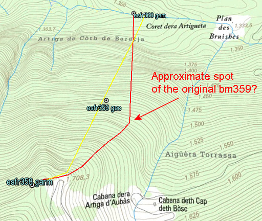
 But there is more to say about the divisoria-line: the curent divisoria-line passes the cross ± 50m to the east. Apparently it has shifted in the course of time. Conclusion: the divisoria-line - now and in the past - should not be considered as authoritive. And why should it anyway? We have no idea how the foresters determined their delimitation on this steep hillside. |
|
WHY IS THE BORDERLINE STRAIGHT BETWEEN BM358 AND 360? |
|
 |
We are used to the straight line between bm358 (a bit beyond it)
and bm360 on the topographic maps. But is this what the
delimitation commission meant in 1863? The treaty is at first sight not explicit about the course of the borderline: it gives only the distance between bm358 and 359 (33om). But there's more: 1. the treaty adds to the text on bm356: "D'ici la frontière monte en ligne droite au piton ou Tuc du Plan de la Serre, et se confond ensuite avec la ligne de crête jusqu'à la croix no 359." 2. and on bm359: "A partir de ce point, la limite internationale abandonne la ligne de partage des eaux jusqu'au Portillon descendant d'abord sur le versant occidental". What does that mean? Well: from bm357 until bm359 the borderline follows the ridge cq watershed. Beyond bm359 it descends on the western hillside (to bm360). |
 |
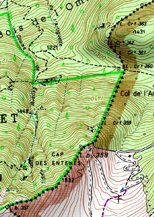
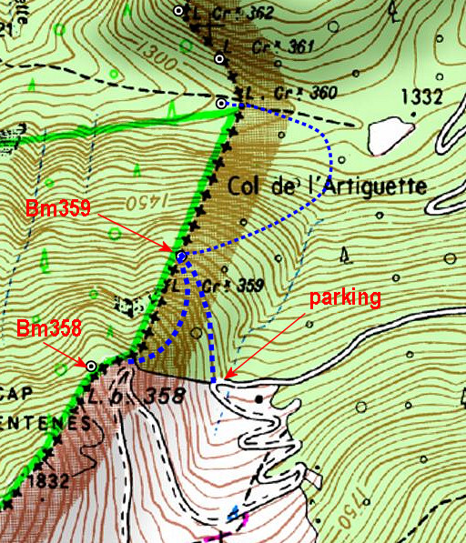
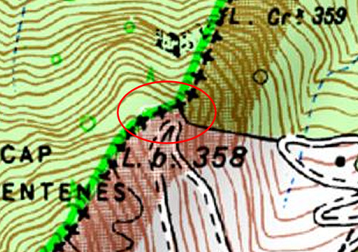
The ridge from bm357 to 358 is very obvious. But what should be considered as the ridge cq watershed below bm358? We now need the Catalonian topographic map with its very detailed elevation line. The yellow line is the borderline as found on the maps. The red line is my interpretation of what the Treaty tells us: the borderline first following the watershed until bm359, then descending on the western hillside to bm360. |
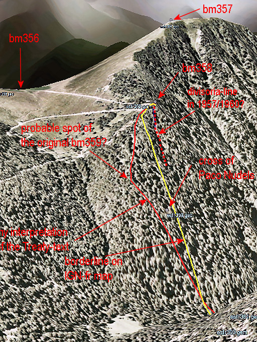 |
Perhaps does this 3d Google Earth-view give a better idea of the ridge = borderline from bm357 via 358 to (the original) bm359. |
| Conclusion: the phrase
"A partir de ce point, la limite internationale abandonne la ligne de
partage des eaux jusqu'au Portillon descendant d'abord sur le versant
occidental" doesn't make sense without a more eastern position of the original bm359 compared to the cross, found by Paco Nudels. |
|
QUESTIONS ABOUT THE PACO NUDELS-CROSS |
|
| 1. Why didn’t Jean Sermet let engrave a number if he was convinced that
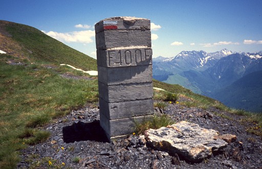
this was the original place of bm359? That doesn’t fit in his thoroughly way of working as we know it. Though Charles Darrieu informed me that Sermet didn't systematically add a number to a new cross, he did so in the vicinity of bm359. We know that the bordercrosses 361 and 363 were also re-engraved in 1957 (because the original ones could not but found) including the number. |
|
 |
2. Why is 'our' cross a latin cross? All bordercrosses between bm315 et 417 are greek crosses, including the crosses of bm361 and 363 which were also re-engraved in 1957. |
 |
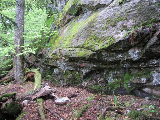
3.
Where is the old cross? In 1960 Sermet discovered an old cross 1 meter above the cross he engraved in 1957. But nowadays there's no trace whatsoever of a cross above the one we know. And that spot is unlikely high, you need a ladder or likewise to engrave there properly. Jan-Willems points to that spot. |
 4. Is the rock-wall of 'our' cross the same as the 4x10m rock-wall which Jean Sermet describes? Well, I haven't seen a similar rock-wall around here and the dimensions fit roughly. But it all assumes that the rock-wall of Sermet is on or near the current divisoria-line. However: the evidence suggests that Sermet followed a divisoria-line which was different from the actual one (more to the W). But remember: the Procès-Verbal only mentions a "rocher touchant le précipice", I would translate that as: 'a rock (or boulder) on the edge of the precipice´. That could be any rock or boulder. |
|
MY CONCLUSIONS |
|
| 1. The original bm359 was engraved in 1863 somewhere to the SE (± 75m?) of the cross, found in 2009 bij Paco Nudels. 2. The cross found by Paco Nudels is not the one which Jean Sermet engraved in 1957 and rechecked in 1960. 3. The spot where Jean Sermet engraved a cross in 1957 , is probably to the W of the cross of Paco Nudels. 4. But awaiting ultimate evidence (finding the original bm359 or the pictures from Jean Sermet) we'll assume for the time being that this marker is meant to be a replacement of the lost bm359, whoever engraved it. We must remember that Jean Sermet took pictures, they must be somewhere hidden in archives. Moreover: he mentions in the 1960-report the existance of a picture from a photographer of Lérida. |
|
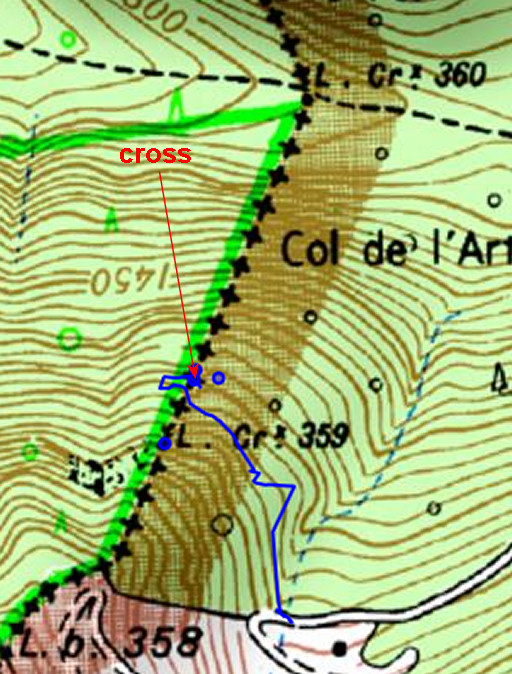
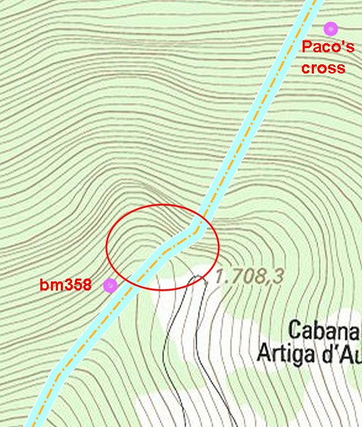
How to get to bm359 (= 'Paco Nudels' cross = the cross assumed to be meant as a successor of the original bm359) |
|
 | From bm538, there are two possibilities. 1. Descend directly with a slight curve towards bm359. 2. First continue along the dirtroad until the parking. Then it's ± 300m to bm359 with a descent of 70m. You can of course combine the two: descend along 1. , then exit towards to the parking. But - if your next goal is bm360 - you might as well try to descend with a half-circle directly. Warning: progress in the steep to very steep forest is complicated by the effects of the ferocious Xinthia-storm in february 2010. Many trees have fallen down, blocking a straightforward route to bm359. Without a gps with a waypoint of bm359, it will be difficult to find the cross. Be careful. |
THEORY 2
|
|
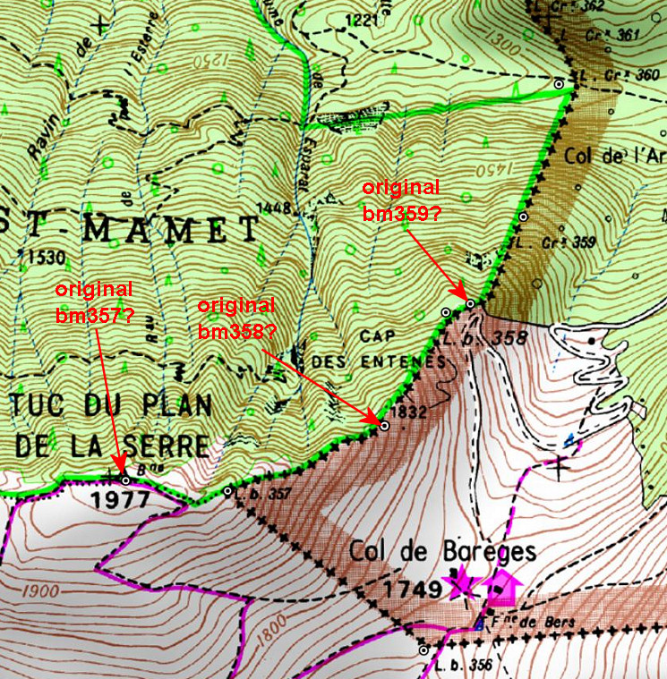
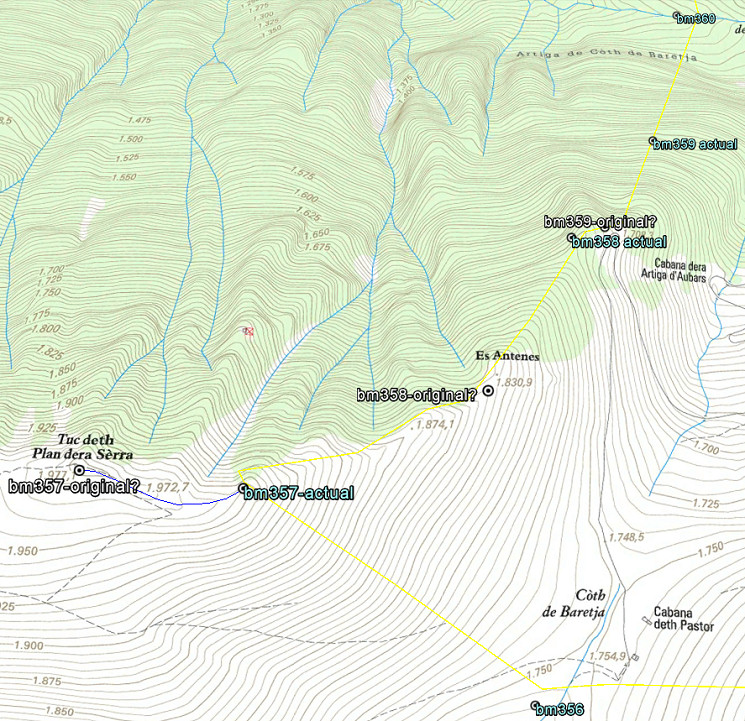
| In short: both bm357 and 358 were reconstructed on the wrong places in the 1950-ies and the original bm359 was thus engraved at the beginning of the steep hillside, not in the middle. Let’s show it on the map: | |
 |
|
 |
After WWII all bordermarkers were surveyed and
reconstructed when needeed. Jean Sermet writes in his “Journal de la
restauration de l’abornement de la Haute Garonne” (1957) that – in the
Haute-Garonne – all borderpillars had disappeared in the well accessible
parts of the borderline. In the proces of replacing the original spots
had to be established again, using the descriptions of the treaty of
1863. In some rare cases the remains of the original masonry pillars were still there, like at bm400. |
 |
The treaty of 1863 says that bm357 was placed at the “piton ou Tuc du
Plan de la Serre” and that’s a well recognizable and plausible summit.
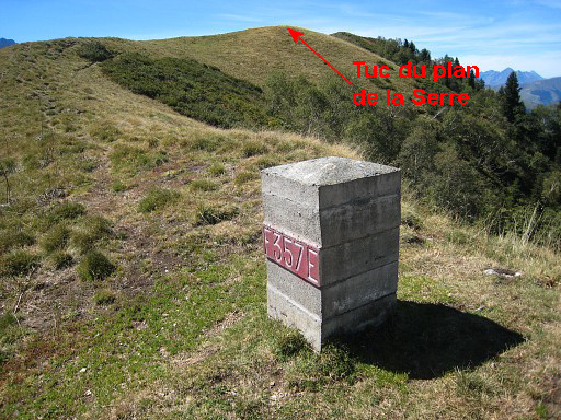
BUT: the actual bm357 (from the 1950-ies) is constructed at the ridge ±
250m E downhill. You can see that perfectly on this picture. |
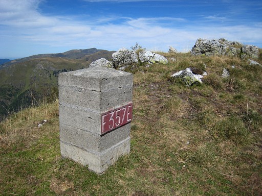 |
One could argue that bm357 is at a sub-summit (this picture shows that better) but it's definitely not at THE summit.
Why is it not at the summit? I can’t find any explication but there’s an account of a discussion on this subject in the report on “Abornement des pâturages espagnols en Haute-Garonne” from Jean Sermet on page 7. His Spanish counterpart M. Alija believed that bm357 should have been placed at the summit. |
| If we assume that the original bm357 was at the summit, it changes
inevitably the position of bm358 and 359 because the treaty states
explicitly the distances in between. Using the distance-calculator
within Google Earth and counting the 602m along the ridge, the original
bm358 would have been placed at a sub-summit (‘Es Antenes’ on the
Catalonian topographic map, the treaty says: “au camp de Enténès”).
Subsequently – after 330m – the original bm359 must have been engraved
in a rock at the end of the ridge. And that’s a bit further – I think – than the new bm358. And that’s where the (very) steep hillside starts towards bm360. Let's show it on the Catalonian topographic map: |
|
 |
|
 |
The Bayonne treaties are amazingly precise on the distances between the
bordermarkers. For example: bm354-355: 135m bm355-356: 1058m bm356-357: 710m bm357-358: 602m bm358-359: 330m How was this measuring in the field done in the 19th century? Well, probably with a simple instrument called “chains”. The question arises: can we reproduce the above distances in a using digital tools and in this way check if bm357 and 358 were placed on the right spots? |
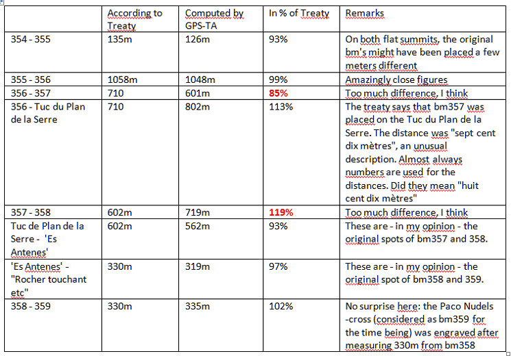
A consistent approach is using altitudes from NASA SRTM1-data (downloaded with DEM1) and assigned to the gpx-tracks with GPS-Track-Analyse.NET. Let’s show the results on a map: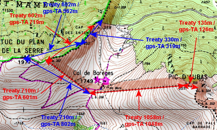 The red arrows and numbers refer to the distances between the existing bordermarkers. The blue arrows and numbers show the measurements of my hypothesis. As you can see: they make much more sense. To finish: a table with all computations and remarks: |
|
 |
|
 |
This theory fits much better in the treaty-description and
in the topography and I’m pretty sure this is the way it was. Jean Sermet writes that the location of bm358 was indisputable (at its current position) but he gives no argument for that. In any case, there are no remains of an original mansonry pillar nowadays. That would have been the very proof indeed. There could have been a toponymical argument: on the French IGN-maps this area is called "cap des entenes" but the Spanish ICC-map shows "Es Antenes" to the SW. |
 |
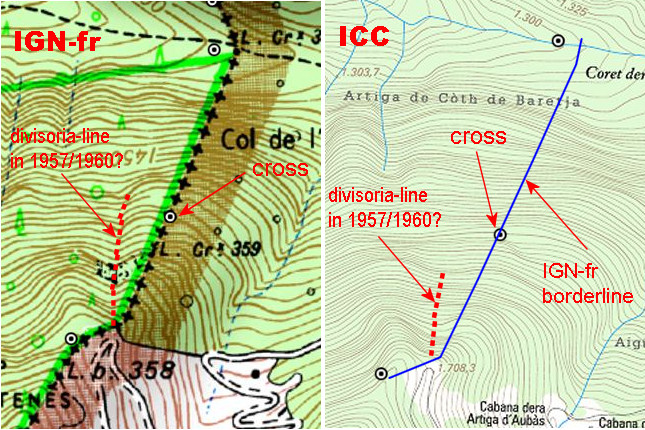
To finish: where to search for bm359. This map: French IGN topographic map. |
 |
Catalonian ICC topographic map. |