|
The
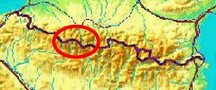
bordermarkers of the Pyrenees : the GRPdesBF
 |
||||||||||||||||||||||||||||||||||||||||||||||||||||||||||
| -
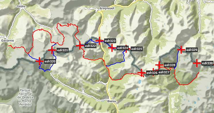
stage 23 - Cabane des Aguilos - Port de Bielsa (bm322-323) |
 |
|||||||||||||||||||||||||||||||||||||||||||||||||||||||||
Update may 2020: the 5 stages 21-25 (bm320-329) will be replaced by four stages. That will result in a more smooth main route, leaving the high altitude and non-waymarked trails to the variants. Has yet to be worked out. It will result in de following routes: |
||||||||||||||||||||||||||||||||||||||||||||||||||||||||||
 You can already watch these new routes in detail with this kml-file. |
||||||||||||||||||||||||||||||||||||||||||||||||||||||||||
Hereunder the original stage: |
||||||||||||||||||||||||||||||||||||||||||||||||||||||||||
 |
||||||||||||||||||||||||||||||||||||||||||||||||||||||||||
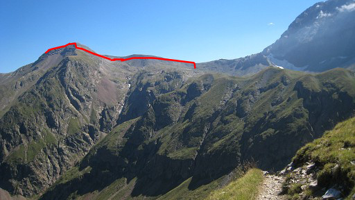
| Only
the bordermarkers along this stage are shown (and some adjoining ones).
The main route is red,
the variants have other colors.
The main route provides a smooth
on-going route along most bordermarkers, the variants give access to
the remaining bordermarkers. See the GRPdesBF-principles. Click here for an fullscreen interactive map. In short An attractive stage with various mountain-passes to climb. The second part - from Col de Barroude onwards - follows the borderridge - including the Pic de Port Vieux (± 2700m) - until Port de Bielsa. There's one short variant to bm322 which is at the western side of Port de Barroude. Considerations The high mountain-ridge from Port de Barroude to Port de Bielsa is high and exposed which make you vulnerable in bad weather. Water is available at the beginning and further approaching and near Refuge de Barroude. Between Port de Barroude and Port de Bielsa: none. A bivouac is possible around Refuge de Barrecoude and you can shelter of course in the Refuge. At the end - at Port de Bielsa - there's no appropiate spot for a bivouac and no water. The next stage continues on the ridge for a few hours (but Lac de Hechempy on the French side might offer you bivaouac-opportunities, ±1,5h from Port de Bielsa) You could also - from Port de Bielsa - descend on a trail S into the valley until you find flatter terrain and water. As an alternative you could descend from the vieux Port on a green/white-trail SE and find a bivouac spot, continuing the next day to Port de Bielsa and further on. Factsheet
Gps-files needed
Version 02 July 2014. If you have any correction, suggestion etcetera -> please email me: eefberns@grenspalen.nl MAPS AND DIRECTIONS You might check the relevant webpages in the 'All markers'-section and 'All my trips'-section for more pictures of the bordermarkers and wayfinding-issues. Print your own maps It's easy to print your own - custom made - maps with the GRPdesBF-route and the bordermarkers on them. See: Print your own maps |
||||||||||||||||||||||||||||||||||||||||||||||||||||||||||
 |
||||||||||||||||||||||||||||||||||||||||||||||||||||||||||
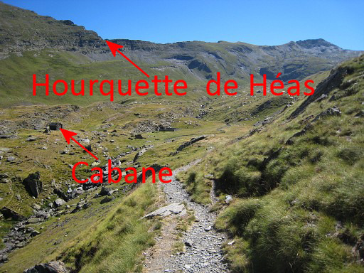 |
This is your starting
point: at the cabane. There are two trails leading to Hourquette de Héas. Avoid the one which makes an unnecessary bend. |
|||||||||||||||||||||||||||||||||||||||||||||||||||||||||
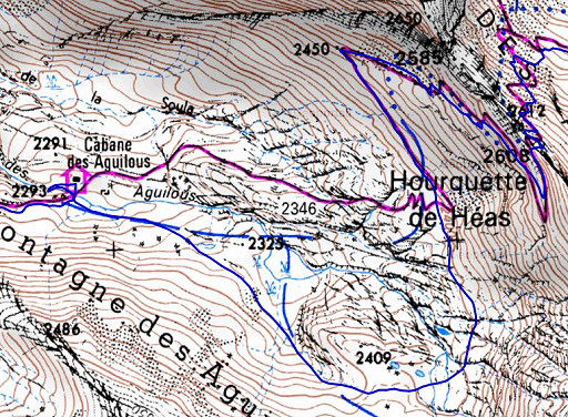 |
The map shows the more
direct trail from the
cabane. The blue trail makes a detour, as you can see. |
|||||||||||||||||||||||||||||||||||||||||||||||||||||||||
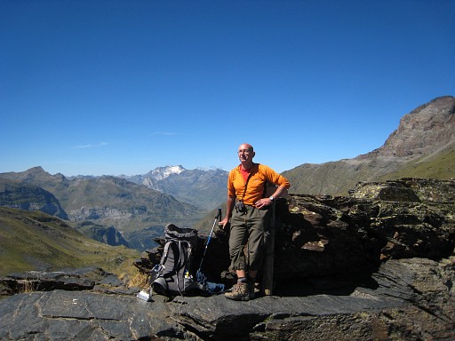 |
On the Hourquette de Héas. A last view of the Vignemale in the background. |
|||||||||||||||||||||||||||||||||||||||||||||||||||||||||
 |
Then after some
descending, continue to the next pass
(Hourquette de Chermentas). Then, after some descending the main trail leads directly southward to the Refuge de Barroude. This picturer: that trail underneath the mountain ridge at your right. |
|||||||||||||||||||||||||||||||||||||||||||||||||||||||||
 |
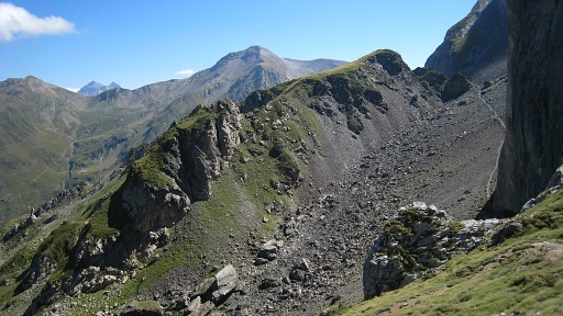
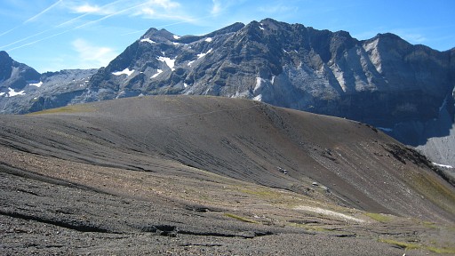
Getting closer to
the refuge, the broad, saddle-like Port de Barroude comes more in sight. From there (the red line) you can continue over the borderridge and via Pic de Port Vieux onwards. |
|||||||||||||||||||||||||||||||||||||||||||||||||||||||||
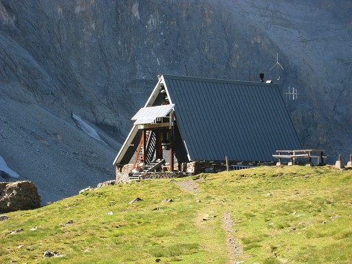 |
You will pass Refuge de
Barroude and not far beyond it: |
|||||||||||||||||||||||||||||||||||||||||||||||||||||||||
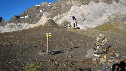 |
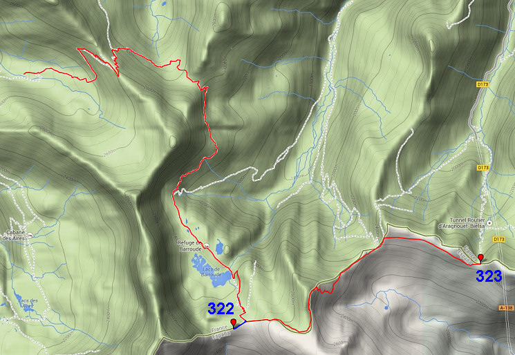
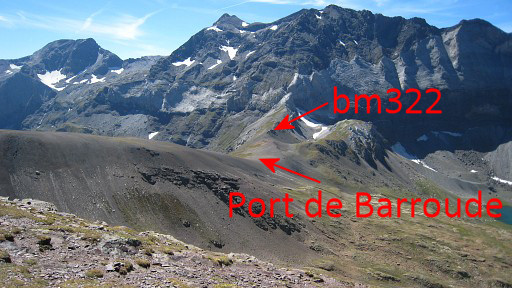
Port de Barroude. This picture: looking W to the small rocky hill where bm322 can ben found. |
|||||||||||||||||||||||||||||||||||||||||||||||||||||||||
| Variant
1 via bm322 |
||||||||||||||||||||||||||||||||||||||||||||||||||||||||||
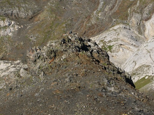 |
That larger rocky outcrop with a metal pole sticking out, ± 200 meter to the west of the Port itself, consists of two little pics, the bm situated just underneath the top of the second. | |||||||||||||||||||||||||||||||||||||||||||||||||||||||||
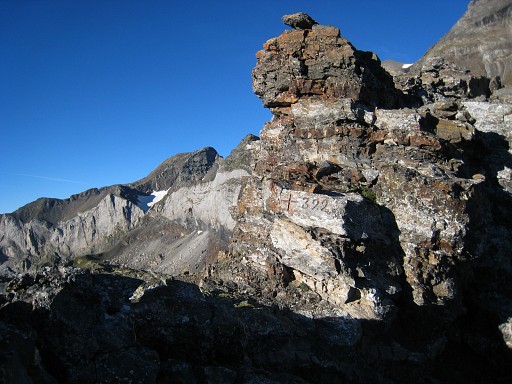 |
Bm322 Then back to the Port. |
|||||||||||||||||||||||||||||||||||||||||||||||||||||||||
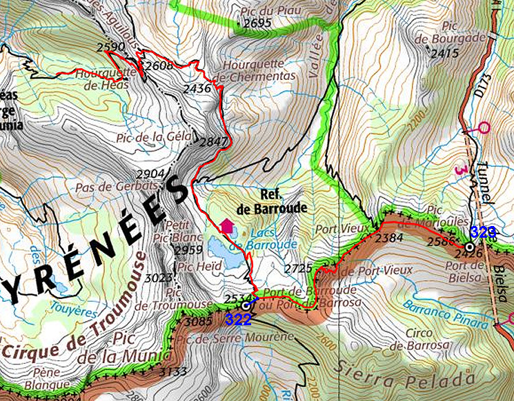
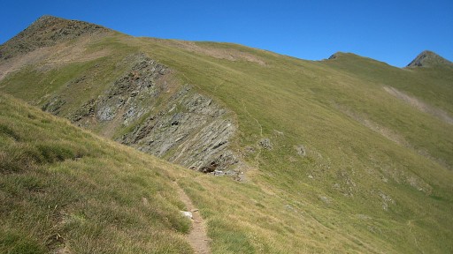
 |
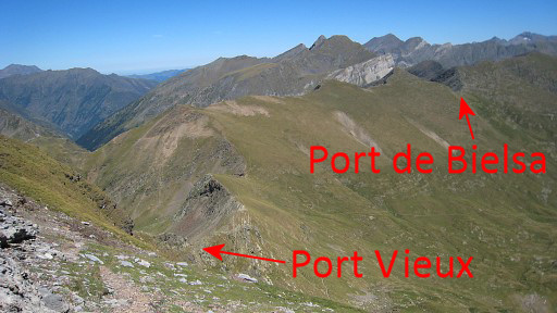
Then proceed - on a trail
over or beneath the ridge - to the E. This direct route from Port de Barroude to the Vieux Port takes about 1 ¼ hour. In bad weather one might make a detour via the vallye which will take ± 4 ½ hours! This picture: looking back, you can see the trail going underneath the ridge. |
|||||||||||||||||||||||||||||||||||||||||||||||||||||||||
 |
The “ridge-route” passes
the summit of Pic de Port
Vieux (2723m). On this picture, taken probably from the Pic de Port Vieux and looking to the Port de Barroude in the distance. |
|||||||||||||||||||||||||||||||||||||||||||||||||||||||||
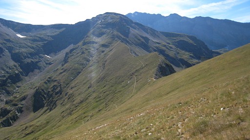
 |
Now looking forward. Essentially you will traverse in as along the mountainside from Port Vieux to Port de Bielsa. An alternative could be: descend on waymarked trails (green/white) to the valley and climb on a branch to Port de Bielsa. Might be easier than the traverse on the grassy slope. |
|||||||||||||||||||||||||||||||||||||||||||||||||||||||||
 |
The Port Vieux From there, simply cross the grassy slope in the direction of Port de Bielsa, gradually climbing. There are no trails. |
|||||||||||||||||||||||||||||||||||||||||||||||||||||||||
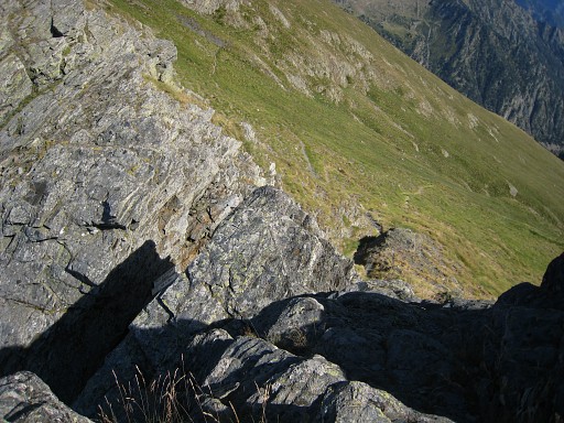
 |
This picture: looking back
at
Port Vieux and the Pic de Port Vieux. Close to the Port de Bielsa, you might need to descend a bit to pass underneath a rocky ridge. |
|||||||||||||||||||||||||||||||||||||||||||||||||||||||||
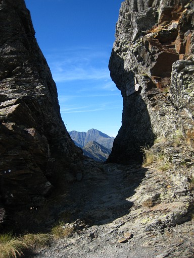 |
Port de Bielsa But you won't find bm323 here in the passage itself. It's on top of the left ridge. |
|||||||||||||||||||||||||||||||||||||||||||||||||||||||||
 |
Bm323 is on top
of
the western side of the corridor. It requires a little climbing from the French side. |
|||||||||||||||||||||||||||||||||||||||||||||||||||||||||
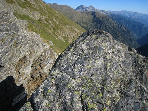 |
Bm323 |
|||||||||||||||||||||||||||||||||||||||||||||||||||||||||